Table of Contents
Races | Culture | Institutions | Buildings & Organizations
BUILDING OF THE LAND ALLOCATION OFFICE OF THE FREE STATE
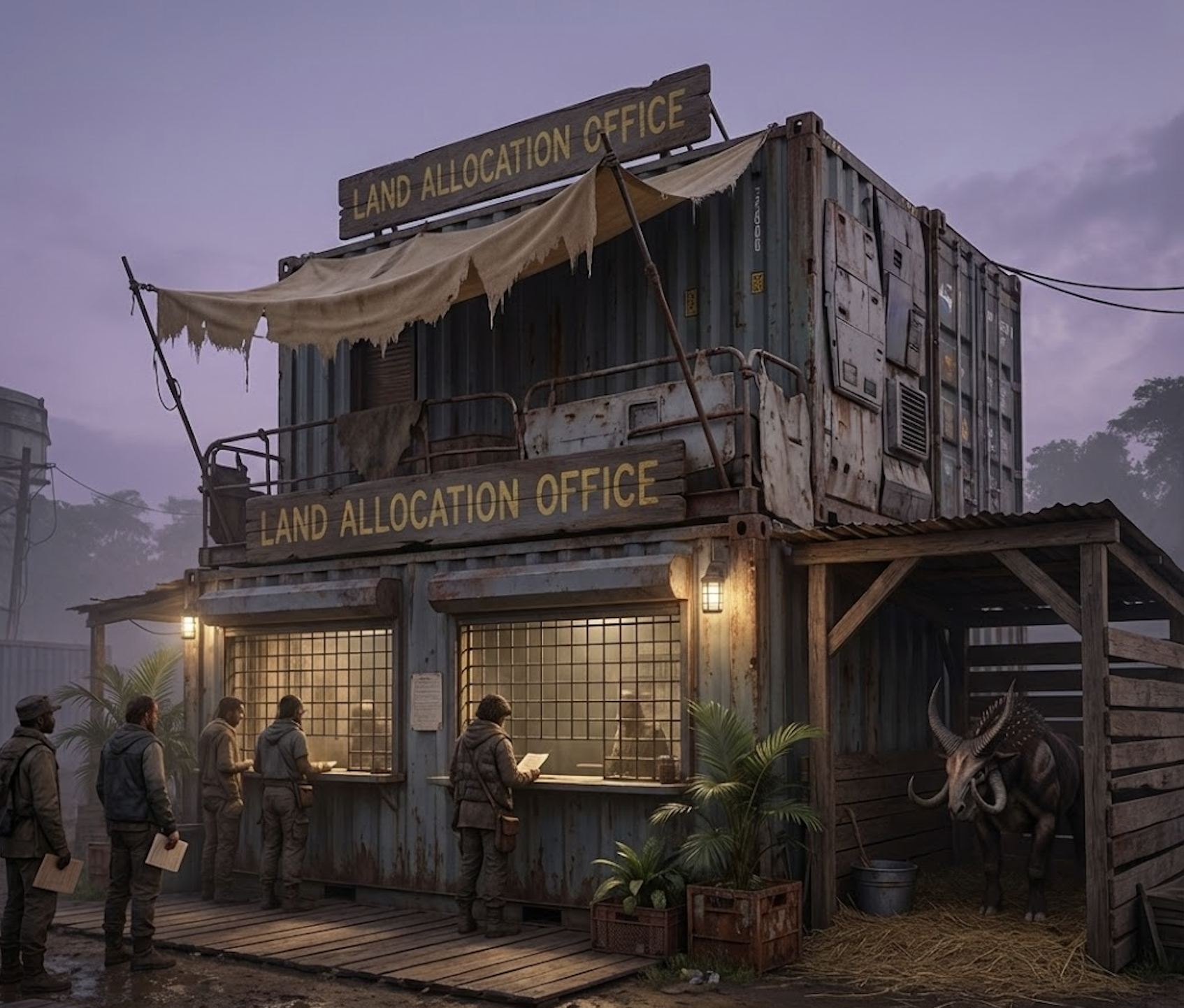
Overview
- Location: Eastern Civic Ring, New Kourou
- Address: SE Talara Road 2
- Surroundings: Positioned near the Settler's Council Hall and the Guarding Troopers' Headquarters, this office played a vital role in the early organization of settler society.
The Land Allocation Office of the Free State of Settlers was responsible for managing the distribution of land and property claims across the Asari Region on VOI 700 D. It played a foundational role in shaping exohuman settlement patterns, economic development, and agricultural expansion during the Beta Age. From this modest administrative building in New Kourou, settlers registered farms, businesses, and homes—often marking the beginning of their independent life on the planet.
The office began operation on May 1, 2625, roughly one month after the crash landing of the Last Frontier (Day Zero). It was closed down at the outbreak of the Great War in June 2629, as the administrative functions were suspended and many staff members joined emergency services or the Volunteer Army of Man.
Architectural Significance
- Construction Material: Weathered starship plates and repurposed office modules from the Last Frontier
- Floors: 2
- Design Purpose: A fast-built, functional administrative node designed for high-volume public processing with outdoor-facing workflows
The building has no public entrance. All interactions occur at two exterior counter windows, protected by a metal grid and covered by a beige cloth canopy. A wooden mount shelter stands beside it.
Building Structure
Ground Floor (Public-Facing Exterior):
- Counter Windows (2): All land applications, claim disputes, and deed pickups occur through these grid-secured counter slots. Both windows are sheltered by a beige cloth canopy.
- AuroraSan Toilet (Public Stall): A compact, privacy-screened outdoor unit attached to the left side of the building, providing minimal sanitation for settlers waiting in long queues.
- Mount Shelter: A simple wooden lean-to with straw bedding and a water bucket for 1–2 Hoos or Veyras.
- Staff Entrance (Rear): A locked door accessible only to clerks and administrators.
Interior Ground Floor (Staff Only):
- Processing Desks: Worktables for reviewing applications, preparing deeds, and stamping approvals.
- Document Sorting Area: Filing racks for incoming and pending claims.
- Break Corner: Hydration unit, ration shelf, and a small table.
Second Floor (Administrative Wing):
- Land Records Archive: A densely packed archive of physical claim folders and regional map plates.
- Cartography Nook: Desk and tools for producing updated settlement maps of the Asari Region.
- Registrar’s Office: Workspace of the Chief Registrar.
- Skills-Test Records Closet: Storage for agricultural skill-test documentation (tests conducted off-site).
Look and Feel
The Land Allocation Office feels gritty, utilitarian, and perpetually strained by demand. Settlers queue along weathered wooden planks, clutching folded documents while Hoos shift restlessly under the shelter.
Inside, the building is cramped and paper-heavy—rows of overstuffed folders, pinned maps, and clipped bundles of deeds. A mix of dry ink, dust, and sweat perfumes the air. Hope and frustration coexist at the counters: one window may issue a long-awaited homestead approval, while the other hears heated disputes over overlapping claims.
Roles and Responsibilities
- Chief Registrar (1): Oversees all land distribution activities and supervises the administrative process
- Lottery Coordinator (1): Organizes and manages weekly land allocation events
- Land Clerks (4): Handle public inquiries, application reviews, and deed issuance
- Cartographer (1): Updates and maintains detailed land maps of the Asari Region
- Agricultural Examiner (1): Conducts practical and theoretical skills tests for farmland eligibility
- Records Manager (1): Maintains the physical and digital archive of land ownership records
- Interns and Volunteers (2–3): Assist with public events, filings, and operational overflow during peak hours
Public Access, Operating Hours and Operational Rhythm
- Public Access: Only via counter windows; settlers may not enter the building.
- Operating Hours: Monday–Friday, 09:00–17:00.
- Lottery Events: Not held here — all land lotteries take place in the Settler’s Council Hall.
Security Measures
- Routine Trooper Patrols: Guarding Troopers pass by several times daily.
- Rear Door Security: Reinforced mechanical lock; clerks hold the only keys.
- Queue Management: On unusually crowded days, a patrolling trooper may regulate lines.
- Civilian Weapons Culture: Many settlers carry rifles or DIY weapons, contributing to tension at the counters.
Player Interaction Possibilities (Legal and Illegal)
Legal Interactions
- Apply for or dispute land claims
- Research land deeds or ownership
- Help NPCs prepare claim paperwork
- Petition the Registrar for special exceptions
- Investigate contested boundary issues
Illegal Interactions:
- Forge or falsify land claim documents
- Steal or alter entries in the Land Records Archive
- Bribe a clerk to rig lottery results
- Sabotage rival settlers’ applications
- Break into the building during closing times to plant or steal documents
Tactical Advice for Dungeon Masters
The Land Allocation Office is ideal for campaigns involving early colonization politics, disputes over land claims, or exploration rights. Players might:
- Forge or challenge land deeds.
- Expose corruption in the lottery process.
- Help an NPC prove their right to farmland by passing a skills test.
- Encounter secret territorial claims or evidence of suppressed maps.